ShareThis

Showing posts with label Pyrenees Top50 by Prom. Show all posts

Monday, 8 October 2018

Santo Domingo


Walk Summary
One of those hills you need to be sure you want to go up given there is a 30km drive from Navardún along the seemingly endless, bumpy albeit tarmacadam A - 2603 to the medieval village of Longás at the end of the road. 
Walk start point in front of 15C manor house in Longás,
It is for sale €60,000 to be lord of the manor! Any offers?
Plan was to follow the track from Longás as far as possible either by van or by foot , however a little extra research the night before identified  a path at the end of street past the church, Iglesia Parroquial de Santa María.
Crossing Barranco de Facillón at O Paso de las Arrogatas
From the village boundary the path is well signposted and well established all the way to the 1223m spot ht and Portillón de Longás at 42°26.83744'N, 0°56.04476'W.
All of the path is not shown on the map but takes you through stunning landscape where route finding is straight forward but some care on steep sections needs to be taken on steep parts of path along ravine of Fuenmayor leading down to Paso de las Arrogatas and crossing of Barranco de Facillón.
Pyrenean vista to the north from Santo Domingo viewing point
From the spot height Portillón de Longás a decent quality road (which makes me wonder if it is this good all the way back to Longás) can be followed all the way to the summit, though I took the path off to the right about 100m from the spot height through more woods to cut of some switchbacks before rejoining road approx 500m before Ermita de Santo Domingo.
Local information as did Peakhunter suggests the summit is at 1523m spot height (NW of Ermits) in spite of trig Pillar (SW of Ermita) being at 1524m and shown on Peakbagger. I knew this was the case but for some reason was drawn to the left hand summit approaching the Ermita expecting that to be the summit. So after admiring the Pyranean vista to the north and recognising Collarada and Peña Oroel was somewhat perplexed when I could not see the trig pillar and then annoyed when I turned round  and saw what was the summit beyond the Ermita. 
Visit them both to be sure. I did as well as adding a new peak for the trig on Peakhunter.
Back to point where left track for path on left to summit.
Portillón de Longás just before distinctive rock formation
of Raya Alta straight ahead
Other than following the road from the Ermita all the way back to the spot height, the descent route was exactly the same as the descent route I did consider following the road back from Portillón de Longás but the 11km on the signpost convinced me it would be better to take the 5km option ack the way I came down the path.


Walk Statistics
Walk Date - 08 October 2018
Walkers - Steve Smith
Accommodation - Camping Cantolagua, Sangüesa 
Start Point - Outside 15c Manor House, Longás (N42°28'51" W0°56'09")
Start Time - 12:13
Finish Point - Outside 15c Manor House, Longás (N42°28'51" W0°56'09")
Finish Time- 17:36
Total Duration - 5hrs 23mins 
Overall Average pace - 1.76mph
Total Distance Walked - 9.49 miles
Total Height Ascended - 1058.00metres

Peaks visited
Spain/Portugal 600m Prominence Peaks (168S - 185S&P - 2165E)
Santo Domingo (26S - 27S&P - 56E)
Pyrenees Top 50 by Prominence (50)
Santo Domingo (9)
Spain/Portugal 300m - 599m Prominence Peaks (1000+)
NONE
Spain/Portugal 150m - 299m Prominence Peaks (3000+)
NONE
Spain Autonomous Community High Points (19)
NONE
Spain Province High Points (52)
NONE
S: Spain
P: Portugal
E:Europe

Other walks on this trip
2018
September
17th Signal d'Ecouves & Mont des Avaloirs
18th Mont Baïgura
19th Autza
October
07th Itzaga
08th Santo Domingo
12th Moncayo
13th Caimodorro
14th Almenara
15th Blanquilla
18th María
19th Sagra
21st La Atalaya
24th Terrier de Saint-Martin-du-Fouilloux & Maine-et-Loire High Point
Route
More Photographs
Look back for last look at Longás after half hours walking on way to Santo Domingo
Click on photograph to view slide-show

Sunday, 7 October 2018

Itzaga


Walk Summary
Planned start point in Zuaza
looks like can drive up track towards Itzaga summit
Chucking it down with rain this morning made me think about turning out today but having had the benefit of an extra rest day to recover from a tough day on Peña Telera I really did not want to use the weather as an excuse not to go up Itzaga. 
So taking my time to get ready and slow a drive from campsite to walk start point gave the rain a chance to clear leaving cloud and decidedly Autumnal feel. At this latitude and elevation you really can't use this sort of weather as an excuse not to go out when I think about some of the weather I have turned out in Scotland.
Nothing much more to say about this walk other than it is a straight forward following the track south from Zuazu, made even easier by being able to drive at least 500m down the track before the ruts become too much for a standard road vehicle.
If you had a 4x4 you could even drive all the way to Ermita de San Miguel, but there is no avoiding a 500m walk SE from the Ermita to Itzaga summit and trig pillar.
Looking SE from Ermita up ridge towards Izaga summit.
No path here but one appears further along
Walk or drive there is no obvious route to the summit other than heading uphill, you eventually picking up a path leading over two or three false summits before emerging onto the grassy summit crown surmounted by a trig pillar. 

Walk Statistics
Walk Date - 07 October 2018
Walkers - Steve Smith
Accommodation - Camping Iturbero, Lumbier 
Start Point - Trackside 500m south of Zuazu. (N42°43'52" W1°26'48")
Start Time - 11:45
Finish Point - Trackside 500m south of Zuazu. (N42°43'52" W1°26'48")
Finish Time- 14:24
Total Duration - 2hrs 39mins
Overall Average pace - 2.47mph
Total Distance Walked - 6.54 miles
Total Height Ascended - 762.00metres

Peaks visited
Spain/Portugal 600m Prominence Peaks (168S - 185S&P - 2165E)
Itzaga (25S - 26S&P - 55E)
Pyrenees Top 50 by Prominence (50)
Itzaga (8)
Spain/Portugal 300m - 599m Prominence Peaks (1000+)
NONE
Spain/Portugal 150m - 299m Prominence Peaks (3000+)
NONE
Spain Autonomous Community High Points (19)
NONE
Spain Province High Points (52)
Moncoya (5&6)
S: Spain
P: Portugal
E:Europe

Other walks on this trip
2018
September
17th Signal d'Ecouves & Mont des Avaloirs
18th Mont Baïgura
19th Autza
October
07th Itzaga
13th Caimodorro
14th Almenara
15th Blanquilla
18th María
19th Sagra
21st La Atalaya
24th Terrier de Saint-Martin-du-Fouilloux & Maine-et-Loire High Point
Route


More Photographs
Itzaga summit beyond ridge from walk start point 500m  south of Zuazu.
Hiker on his way down from early visit to summit

Click on photograph to view slide-show

Tuesday, 2 October 2018

Pico Collarada


Walk Summary
Refugio del Cubilar de Espata
Paid my €5 online (Search for "Collarada Track Circulation Permit" or "Permiso de Circulación Pista de Collarada") to give me authorisation to drive up private mountain road from Villanúa to Refugio del Cubilar de la Espata and the confidence to drive beyond “No Unauthorised Vehicle” sign at 42° 41’ 14”N, 00° 30’ 49”W. You could arguably drive to this point but the written sign “ Pista de Collarada Prohibida La Circulacion” at 42° 41’ 00”N, 00° 31’ 33”W was enough to deter me. The road is somewhat rutted in a number of places but is just about suitable for a road vehicle if you go slow. It took me 50 minutes to drive the 10km past numerous switchbacks to the Refugio. Money well spent, no way would I have managed this summit in a day otherwise.
Head west from the refugio for a very short distance and branch of right at what is shown as a dead end track on the map but is little more than a well established path that is easy to follow through woodland to the base of a cliff with an access route to the top assisted by a couple of short lengths of fixed rope at 42° 41’ 33”N, 00° 28’ 40”W. Once at the top the going gradually improves still able to follow a vague path marked by cairns that does disappear on occasion until you get to the first substantial cairn and post arrangement near El Boso at 42° 41’ 40”N, 00° 28’ 37”W.
Another cairn/post guiding route. Head off to right
of picture and aim for Collarada de Ip on distant saddle
Continue NE for about 1000m you come to the final cairn & post (I saw one other, but there may be more) at 42° 42’ 10”N, 00° 27’ 59”W. From here you get the first real sight of Pico Collarada and the route to take through rocky crags and outcrops to it’s right towards El Paso. Beyond El Paso takes you up a scree slope to Collado de Ip and first view, beyond the azure blue Ibón de Ip, of the French Pyrenees and rugged ridge heading east towards Balaïtous, the most westerly 3000m summit. Turning to the left at Collado de Ip you will also see the route ascending through rock up to a good sized scree slope and beyond what looks to be a climb to Pico Collarada summit. Well it usually looks harder from a distance.
The final scramble (climb) to Pico Collarada
Having negotiated the scree slope you could indeed find more difficult routes up the rock face, however I chose the easiest way I could see resulting in a sustained scramble. The temperature had been dropping along with the wind increasing throughout the entire ascent resulting in adding mid layer and finally summer coat on the summit crown.
The wind was very cold and gusty making me take extra care to not be blown to the left and over what looked a precipitous edge. With the effort to get this far it crossed my mind that if there had been any rain mixed in with this lot I would have seriously considered turning back without going for the summit across the final 100m of rocky ground and 20m – 30m of ascent.

Might have set off from van in a T-shirt
reckon with wind chill temp close to 0°C on summit.
Much colder than experienced on trip so far
Conditions did not bode well for good photos or hanging around so after essential summit rituals of logging on peakhunter and peak bagger along with summit pics and a selfie I set off back. It did occur to me the futility of this endeavor but on the other hand it is the reason you keep coming back for more. Not surprising I came down the climb a different way. Not any easier to ascend but just different. The rest of the descent to Collado de Ip was not too difficult though it would have been easier had I remembered my trek poles. Still cold, but with slightly less wind, but enough to keep on my coat. Stop for a spot of lunch out of the wind just before Collado de Ip was enough to reinvigorate me to head down through the rocks (tending to the left) and back on the gentle slope marked by the cairns with posts. Half way down I realised it was not cold anymore, in fact it was decidedly warm back to the T-shirt weather I had been used to up to now on this trip.
So after de-layering and further refreshments it was a straight
Looking back at pre-fixed rope assisted descent down crag
just before tree line and path
back to van at Refugio del Cubilar de Espata
forward return to the top of the roped descent and amble through the woods back to the Refugio and van. Without doubt, the toughest summit attempted and reached so far, not being made any easier by forgetting my trek poles. I managed but hips and quads were definitely singing at the extra workload they had to take on. Now all that remained was the 50 minute drive back down the 10km mountain road. But what a satisfying day. Thoroughly recommend it but don’t forget to buy the authorisation to drive to the Refugio.


Walk Statistics
Walk Date - 02 October 2018
Walkers - Steve Smith
Accommodation - Camping Aín, Jaca
Start Point - Refugio del Cubilar de Espata (N42°41'18" W0°28'30")
Start Time - 09:38
Finish Point - Refugio del Cubilar de Espata (N42°41'18" W0°28'30")
Finish Time- 15:25
Total Duration - 5hrs 47mins
Overall Average pace - 0.92mph
Total Distance Walked - 5.30 miles
Total Height Ascended - 1166.00metres

Peaks visited
Spain/Portugal 600m Prominence Peaks (168S - 185S&P - 2165E)
Pico Collarada (23S - 24S&P - 53E)
Pyrenees Top 50 by Prominence (50)
Pico Collarada (7)
Spain/Portugal 300m - 599m Prominence Peaks (1000+)
NONE
Spain/Portugal 150m - 299m Prominence Peaks (3000+)
NONE
Spain Autonomous Community High Points (19)
NONE
Spain Province High Points (52)
NONE
S: Spain
P: Portugal
E:Europe

Other walks on this trip
2018
September
17th Signal d'Ecouves & Mont des Avaloirs
18th Mont Baïgura
19th Autza
October
02nd Collarada
07th Itzaga
13th Caimodorro
14th Almenara
15th Blanquilla
18th María
19th Sagra
21st La Atalaya
24th Terrier de Saint-Martin-du-Fouilloux & Maine-et-Loire High Point
Route

More Photographs
Looking down towards Refugio Forestal de Zuriza and Camping de Zuriza on way up Peña de Ezcaurre beyond Punta Abizondo on left
Click on photograph to view slide-show

Friday, 28 September 2018

Peña de Oroel


Walk Summary
The plan was to start from the village of Barós (N42°32'44.228" W00°31'35.772), but I subsequently spotted a possible drive up to Refugio Mirador de Oreal saving approx 2.5km of walking.
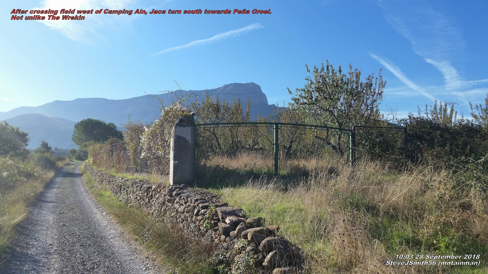
After crossing field west of Camping Aín, Jacaturn south
towards Peña Oroel. Not unlike The Wrekin near Telford
However I found Camping Aín, Jaca just east of 
Barós, so decided to walk the 2.5km to the Refugio rather than go through hassle of striking camp and drive what would be about 20km to the Refugio. 
Well signposted track other side of the field east of Camping Aín, that quickly becomes unsuitable for a standard road vehicle which in turn becomes a well signposted path that is easy to follow up to access road 250m westof Refugio Mirador de Oreal. It is tarmac confirming could drive to the Refugio.
It is here where the ascent went wrong. On the other side of the road I took the clear track that is shown on map and cutting off a corner,  leading to path beyond Refugio, also marked on the map taking you to the established ascent route. In hindsight I should have turned left on the road to the Refugio and pick up the path which takes you to the summit ridge.
At this point I have gone wrong tempted to follow
path off to right but felt I needed to ascend to left of cliffs
I somehow left this track early, turning north along a reasonable path, missing the correct path by only 50m. This led to a dry stream and a path heading right and further SW. I opted to follow the stream to the SE on the basis the SW path was heading for a sheer cliff face. Who knows there might be a route but I do not recommend returning to find out.
Instead  I followed the dry stream bed which brought me to the base of the cliff and steep scrabble (not scramble) up a 45° soil covered incline where the vegetation gives way to the cliff on your right. From the top, more bushwhacking through beech and pine ensued resulting in me coming out half way up a gully.
Looking down on Jaca after a lot of bushwhacking. Not quite
at top, still a scramble and a bit more of a bushwhack to do
Looking up at the cliff I convinced myself I could see a way up the rock face but after approx. 50m of ascent along the tree line ends as does any way forwards or up. I still thought I could just make out a way up the cliff face, but discretion being the better part of valor I shuffled back down the slope on my backside hanging on to sturdy saplings to the bottom then continue up and over the next tongue, where the trees thin and slope becomes more grassy. Not quite the end of the story as there is still quite a bit of steep ascent which becomes scrambling up a mixture of sedimentary conglomerate requiring careful verification of hand holds.
Turn right and west along summit ridge towards
Peña Oroel summit
At the top of this steep scramble time for a rest from what was extreme exertion before making the final 100m assault through thick trees to the summit ridge. 
What a battle. Definitely do not recommend this route. A real challenge with excitement and maybe just a little too much jeopardy.
To my left I could see a sign which would hopefully point me in the direction of an ascent route. To the right were clearly defined paths through bushes and small trees and beyond the next ridge there was a good path through grass and beyond two headlands the Crux de Oreol and the summit.
After nearly 30 minutes on the summit taking photographs, relaxing in the sun and having some lunch I returned back along the ridge heading for the signpost I spotted earlier after summit ridge.
Plenty of parking at Refugio Mirador de Oroel
No way down from here but walking further east down the left fork at the signpost the path doubles back on itself starting the straight forward descent all the way to 
Refugio Mirador de Oreal down what should have been the ascent route.
Heading west from the Refugio along the access road take care not to miss path back to the campsite and the path we used on the ascent back to the campsite after approx. 250m.

Easy day I thought.
Let's walk up nearby summit from campsite.
6.42km, 964m of ascent and 3hrs 46 mins later reach Peña de Oroel summit.


Walk Statistics
Walk Date - 28 September 2018
Walkers - Steve Smith
Accommodation - Camping Aín, Jaca 
Start Point - Camping Aín, Jaca (N42°33'08.602" W00°33'08.738")
Start Time - 09:56
Finish Point - Camping Aín, Jaca (N42°33'08.602" W00°33'08.738")
Finish Time- 16:19
Total Duration - 6hrs 23mins 
Overall Average pace - 1.36mph
Total Distance Walked - 8.66 miles
Total Height Ascended - 966.00metres

Peaks visited
Spain/Portugal 600m Prominence Peaks (168S - 185S&P - 2165E)
Peña de Oreol (22S - 23S&P - 52E)
Pyrenees Top 50 by Prominence (50)
Peña de Oroel (6)
Spain/Portugal 300m - 599m Prominence Peaks (1000+)
NONE
Spain/Portugal 150m - 299m Prominence Peaks (3000+)
NONE
Spain Autonomous Community High Points (19)
NONE
Spain Province High Points (52)
NONE
S: Spain
P: Portugal
E:Europe

Other walks on this trip
2018
September
17th Signal d'Ecouves & Mont des Avaloirs
18th Mont Baïgura
19th Autza
23rd Pic d'Anie
26th Bisaurín
28th Peña de Oroel
October
07th Itzaga
13th Caimodorro
14th Almenara
15th Blanquilla
18th María
19th Sagra
21st La Atalaya
24th Terrier de Saint-Martin-du-Fouilloux & Maine-et-Loire High Point
Route

More Photographs
Finally summit comes in to viewClick on photograph to view slide-show