Walk Summary
One of those hills you need to be sure you want to go up given there is a 30km drive from Navardún along the seemingly endless, bumpy albeit tarmacadam A - 2603 to the medieval village of Longás at the end of the road.
Plan was to follow the track from Longás as far as possible either by van or by foot , however a little extra research the night before identified a path at the end of street past the church, Iglesia Parroquial de Santa María.
From the village boundary the path is well signposted and well established all the way to the 1223m spot ht and Portillón de Longás at 42°26.83744'N, 0°56.04476'W.
All of the path is not shown on the map but takes you through stunning landscape where route finding is straight forward but some care on steep sections needs to be taken on steep parts of path along ravine of Fuenmayor leading down to Paso de las Arrogatas and crossing of Barranco de Facillón.
From the spot height Portillón de Longás a decent quality road (which makes me wonder if it is this good all the way back to Longás) can be followed all the way to the summit, though I took the path off to the right about 100m from the spot height through more woods to cut of some switchbacks before rejoining road approx 500m before Ermita de Santo Domingo.
Local information as did Peakhunter suggests the summit is at 1523m spot height (NW of Ermits) in spite of trig Pillar (SW of Ermita) being at 1524m and shown on Peakbagger. I knew this was the case but for some reason was drawn to the left hand summit approaching the Ermita expecting that to be the summit. So after admiring the Pyranean vista to the north and recognising Collarada and Peña Oroel was somewhat perplexed when I could not see the trig pillar and then annoyed when I turned round and saw what was the summit beyond the Ermita.
Visit them both to be sure. I did as well as adding a new peak for the trig on Peakhunter.
Other than following the road from the Ermita all the way back to the spot height, the descent route was exactly the same as the descent route I did consider following the road back from Portillón de Longás but the 11km on the signpost convinced me it would be better to take the 5km option ack the way I came down the path.
Walk Statistics
Peaks visited
Spain/Portugal 300m - 599m Prominence Peaks (1000+)
Route
More Photographs
 |
| Walk start point in front of 15C manor house in Longás, It is for sale €60,000 to be lord of the manor! Any offers? |
 |
| Crossing Barranco de Facillón at O Paso de las Arrogatas |
All of the path is not shown on the map but takes you through stunning landscape where route finding is straight forward but some care on steep sections needs to be taken on steep parts of path along ravine of Fuenmayor leading down to Paso de las Arrogatas and crossing of Barranco de Facillón.
 |
| Pyrenean vista to the north from Santo Domingo viewing point |
Local information as did Peakhunter suggests the summit is at 1523m spot height (NW of Ermits) in spite of trig Pillar (SW of Ermita) being at 1524m and shown on Peakbagger. I knew this was the case but for some reason was drawn to the left hand summit approaching the Ermita expecting that to be the summit. So after admiring the Pyranean vista to the north and recognising Collarada and Peña Oroel was somewhat perplexed when I could not see the trig pillar and then annoyed when I turned round and saw what was the summit beyond the Ermita.
Visit them both to be sure. I did as well as adding a new peak for the trig on Peakhunter.
 |
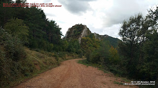
| Back to point where left track for path on left to summit. Portillón de Longás just before distinctive rock formation of Raya Alta straight ahead |
Walk Date - 08 October 2018
Walkers - Steve Smith
Walkers - Steve Smith
Accommodation - Camping Cantolagua, Sangüesa
Start Point - Outside 15c Manor House, Longás (N42°28'51" W0°56'09")
Start Time - 12:13
Start Time - 12:13
Finish Point - Outside 15c Manor House, Longás (N42°28'51" W0°56'09")
Finish Time- 17:36
Total Duration - 5hrs 23mins
Overall Average pace - 1.76mph
Total Distance Walked - 9.49 miles
Total Height Ascended - 1058.00metres
Overall Average pace - 1.76mph
Total Distance Walked - 9.49 miles
Total Height Ascended - 1058.00metres
Spain/Portugal 600m Prominence Peaks (168S - 185S&P - 2165E)
Santo Domingo (26S - 27S&P - 56E)
Pyrenees Top 50 by Prominence (50)
Santo Domingo (9)
NONE
Spain/Portugal 150m - 299m Prominence Peaks (3000+)
NONE
Spain Autonomous Community High Points (19)
NONE
Spain Province High Points (52)
NONE
S: Spain
P: Portugal
E:Europe
P: Portugal
E:Europe
Other walks on this trip
2018
September
17th Signal d'Ecouves & Mont des Avaloirs
18th Mont Baïgura
19th Autza
October
02nd Pico Collarada
04th Peña Telera
07th Itzaga
18th María
19th Sagra
19th Sagra
21st La Atalaya
22nd Cerro de Javalambre
24th Terrier de Saint-Martin-du-Fouilloux & Maine-et-Loire High Point |
| Look back for last look at Longás after half hours walking on way to Santo Domingo Click on photograph to view slide-show |

