
Walk Summary
The plan was to start from the village of Barós (N42°32'44.228" W00°31'35.772), but I subsequently spotted a possible drive up to Refugio Mirador de Oreal saving approx 2.5km of walking.
However I found Camping Aín, Jaca just east of Barós, so decided to walk the 2.5km to the Refugio rather than go through hassle of striking camp and drive what would be about 20km to the Refugio.
Well signposted track other side of the field east of Camping Aín, that quickly becomes unsuitable for a standard road vehicle which in turn becomes a well signposted path that is easy to follow up to access road 250m westof Refugio Mirador de Oreal. It is tarmac confirming could drive to the Refugio.
It is here where the ascent went wrong. On the other side of the road I took the clear track that is shown on map and cutting off a corner, leading to path beyond Refugio, also marked on the map taking you to the established ascent route. In hindsight I should have turned left on the road to the Refugio and pick up the path which takes you to the summit ridge.
I somehow left this track early, turning north along a reasonable path, missing the correct path by only 50m. This led to a dry stream and a path heading right and further SW. I opted to follow the stream to the SE on the basis the SW path was heading for a sheer cliff face. Who knows there might be a route but I do not recommend returning to find out.
Instead I followed the dry stream bed which brought me to the base of the cliff and steep scrabble (not scramble) up a 45° soil covered incline where the vegetation gives way to the cliff on your right. From the top, more bushwhacking through beech and pine ensued resulting in me coming out half way up a gully.
Looking up at the cliff I convinced myself I could see a way up the rock face but after approx. 50m of ascent along the tree line ends as does any way forwards or up. I still thought I could just make out a way up the cliff face, but discretion being the better part of valor I shuffled back down the slope on my backside hanging on to sturdy saplings to the bottom then continue up and over the next tongue, where the trees thin and slope becomes more grassy. Not quite the end of the story as there is still quite a bit of steep ascent which becomes scrambling up a mixture of sedimentary conglomerate requiring careful verification of hand holds.
At the top of this steep scramble time for a rest from what was extreme exertion before making the final 100m assault through thick trees to the summit ridge.
What a battle. Definitely do not recommend this route. A real challenge with excitement and maybe just a little too much jeopardy.
To my left I could see a sign which would hopefully point me in the direction of an ascent route. To the right were clearly defined paths through bushes and small trees and beyond the next ridge there was a good path through grass and beyond two headlands the Crux de Oreol and the summit.
After nearly 30 minutes on the summit taking photographs, relaxing in the sun and having some lunch I returned back along the ridge heading for the signpost I spotted earlier after summit ridge.
No way down from here but walking further east down the left fork at the signpost the path doubles back on itself starting the straight forward descent all the way to Refugio Mirador de Oreal down what should have been the ascent route.
Heading west from the Refugio along the access road take care not to miss path back to the campsite and the path we used on the ascent back to the campsite after approx. 250m.
Easy day I thought.
Let's walk up nearby summit from campsite.
6.42km, 964m of ascent and 3hrs 46 mins later reach Peña de Oroel summit.
Walk Statistics
Other walks on this trip
Route

More Photographs
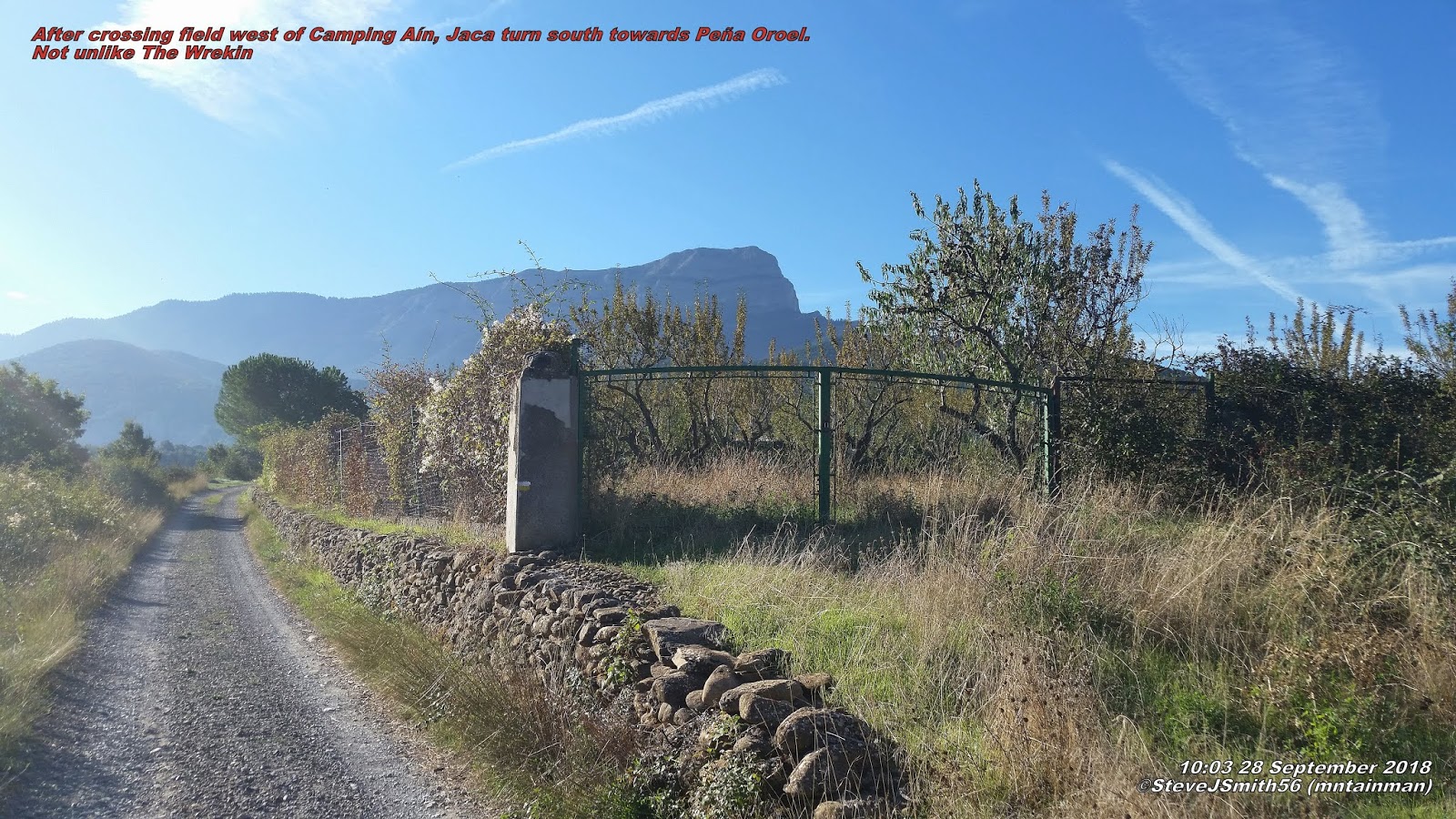 |
| After crossing field west of Camping Aín, Jacaturn south towards Peña Oroel. Not unlike The Wrekin near Telford |
Well signposted track other side of the field east of Camping Aín, that quickly becomes unsuitable for a standard road vehicle which in turn becomes a well signposted path that is easy to follow up to access road 250m westof Refugio Mirador de Oreal. It is tarmac confirming could drive to the Refugio.
It is here where the ascent went wrong. On the other side of the road I took the clear track that is shown on map and cutting off a corner, leading to path beyond Refugio, also marked on the map taking you to the established ascent route. In hindsight I should have turned left on the road to the Refugio and pick up the path which takes you to the summit ridge.
 |
| At this point I have gone wrong tempted to follow path off to right but felt I needed to ascend to left of cliffs |
 | |
|
 |
| Turn right and west along summit ridge towards Peña Oroel summit |
What a battle. Definitely do not recommend this route. A real challenge with excitement and maybe just a little too much jeopardy.
To my left I could see a sign which would hopefully point me in the direction of an ascent route. To the right were clearly defined paths through bushes and small trees and beyond the next ridge there was a good path through grass and beyond two headlands the Crux de Oreol and the summit.
After nearly 30 minutes on the summit taking photographs, relaxing in the sun and having some lunch I returned back along the ridge heading for the signpost I spotted earlier after summit ridge.
 |
| Plenty of parking at Refugio Mirador de Oroel |
Heading west from the Refugio along the access road take care not to miss path back to the campsite and the path we used on the ascent back to the campsite after approx. 250m.
Easy day I thought.
Let's walk up nearby summit from campsite.
6.42km, 964m of ascent and 3hrs 46 mins later reach Peña de Oroel summit.
Walk Date - 28 September 2018
Walkers - Steve Smith
Walkers - Steve Smith
Accommodation - Camping Aín, Jaca
Start Point - Camping Aín, Jaca (N42°33'08.602" W00°33'08.738")
Start Time - 09:56
Start Time - 09:56
Finish Point - Camping Aín, Jaca (N42°33'08.602" W00°33'08.738")
Finish Time- 16:19
Total Duration - 6hrs 23mins
Overall Average pace - 1.36mph
Total Distance Walked - 8.66 miles
Total Height Ascended - 966.00metres
Overall Average pace - 1.36mph
Total Distance Walked - 8.66 miles
Total Height Ascended - 966.00metres
Peaks visited
Spain/Portugal 600m Prominence Peaks (168S - 185S&P - 2165E)
Spain/Portugal 600m Prominence Peaks (168S - 185S&P - 2165E)
Peña de Oreol (22S - 23S&P - 52E)
Pyrenees Top 50 by Prominence (50)
Peña de Oroel (6)
Spain/Portugal 300m - 599m Prominence Peaks (1000+)
NONE
Spain/Portugal 150m - 299m Prominence Peaks (3000+)
NONE
Spain Autonomous Community High Points (19)
NONE
Spain Province High Points (52)
NONE
S: Spain
P: Portugal
E:Europe
P: Portugal
E:Europe
2018
September
17th Signal d'Ecouves & Mont des Avaloirs
18th Mont Baïgura
19th Autza
October
02nd Pico Collarada
04th Peña Telera
07th Itzaga
21st La Atalaya
22nd Cerro de Javalambre
24th Terrier de Saint-Martin-du-Fouilloux & Maine-et-Loire High Point |
| Finally summit comes in to viewClick on photograph to view slide-show |