
Walk Summary
Peaks visited
Spain/Portugal 600m Prominence Peaks (168S - 185S&P - 2165E)
Route
More Photographs
The mountain that kept on giving and demanding more.
Probably the hardest mountain I have climbed on my own.
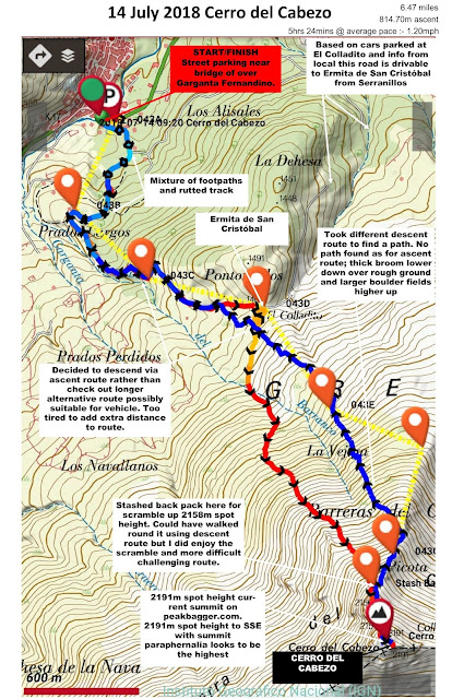
After walking to Ermita de san Cristóbal from the mountain village of Serranillos along rutted track that in places was barely a path, came across some vans and a few cars setting up for a fiesta, so could have driven to El Colladito but not the way I walked. From there it is choose any line towards the summit with average ascent of close to 1 in 5 over 1500m. I followed the wall near Garganta del Barranco and path heading in that direction, however all three soon progressively disappeared, leaving just thigh high broom hiding uneven ground, then large boulders.
Heading for the 2158m spot height which is visible from the very start of the walk in Serranillos I got it in my head this was the summit. So at it's base after a couple of energy bars and drink, I looked for the best line, stashed my back pack & trek poles and committed to the ascent. Reaching the top of the first scramble reveals a slightly harder scramble round to the left towards the summit marked by an iron cross. It was not until I reached the base of the cross and peered over the lip that you finally get sight of the true summit, separated by a down climb then up to the 2154m spot height, followed by another down climb aided by a pre placed chain, the anchor of which I first thought was an abseil station. From it's base it is a straight forward ascent on to the twin spot heights of 2191m, the further one to the SE with all the summit paraphernalia is definitely the higher of the two.
The exhilaration of the scramble and realisation part way through that it is more dangerous to go back than press on tempers the disappointment followed by embarrassment that I had not studied the route more carefully. There was also an element of regret about not having my back pack with me, forcing me to return the way I had come rather than a possible easier more direct descent route off to the right.
Approaching the summit I could see what looked like an eagle so a stealthy approach was employed mixed in with several stops for photographs along with some pride that I was employing appropriate bush craft by approaching it with the wind in my face as though I had control of that. Eventually I managed the money shot right next to a metal plate crafted in the shape of an eagle!
Spending a little longer than usual, given the effort to reach this summit just contemplating and taking in the views before thinking about the best return route. First job was to go to the NW 2191m spot height, just in case someone decides it is higher in the future. From here I could see a route around what is now the right hand side of the ascent scramble and back to my backpack. Had I studied the route more carefully I could have used this route on the ascent but like I say I am really pleased I took the opportunity to test and improve my scrambling capabilities.
Took a different line down further to the east but still found no path. Reverse of the ascent; boulders then broom down to the Ermita.
From the Ermita back along the ascent track, the drivable route was further.
Well chuffed though to be the first to claim a tick on peakbagger.com.
Walk Statistics
 |
| Might be better to follow wall near Garganta del Barranco to delay inevitable but eventually you will hit the broom |
After walking to Ermita de san Cristóbal from the mountain village of Serranillos along rutted track that in places was barely a path, came across some vans and a few cars setting up for a fiesta, so could have driven to El Colladito but not the way I walked. From there it is choose any line towards the summit with average ascent of close to 1 in 5 over 1500m. I followed the wall near Garganta del Barranco and path heading in that direction, however all three soon progressively disappeared, leaving just thigh high broom hiding uneven ground, then large boulders.
 |
| The 2nd scramble you don't see from the bottom of 2158m Cerro del Cabezo spot height |
 |
| Gawd blimey I came over that and did not really have to. Pleased I did though. Chain visible - right quadrant |
 |
| Pico de Almanzor from Cerro del Cabezo, gullies still packed with snow |
Took a different line down further to the east but still found no path. Reverse of the ascent; boulders then broom down to the Ermita.
From the Ermita back along the ascent track, the drivable route was further.
Well chuffed though to be the first to claim a tick on peakbagger.com.
Walk Date - 14 July 2018
Walkers - Steve Smith
Walkers - Steve Smith
Accommodation - Prados Abiertos, Mombeltran
Start Point - Street parking in Serranillos near bridge of over Garganta Fernandino (N40°20'02.825" W4°54'43.062")
Start Time - 09:20
Finish Point - Street parking in Serranillos near bridge of over Garganta Fernandino (N40°20'02.825" W4°54'43.062")
Finish Time- 15:39
Total Duration - 6hrs 19mins
Overall Average pace - 0.83mph
Total Distance Walked - 5.25 miles
Total Height Ascended - 983.10metres
Overall Average pace - 0.83mph
Total Distance Walked - 5.25 miles
Total Height Ascended - 983.10metres
Spain/Portugal 600m Prominence Peaks (168S - 185S&P - 2165E)
Cerro del Cabezo (15S - 16S&P - 43E)
Spain/Portugal 300m - 599m Prominence Peaks (1000+)
NONE
Spain/Portugal 150m - 299m Prominence Peaks (3000+)
NONE
Spain Autonomous Community High Points (19)
NONE
Spain Province High Points (52)
NONE
S: Spain
P: Portugal
E:Europe
P: Portugal
E:Europe
Other walks on this trip
2018
June
26th Ganekorgorta
28th Eretza
29th Mortillano
July
01st Castro Valnera
03rd El Cueto

 |
| Time to put camera away and concentrate. Seems like a grade II scramble to me. Grade III as I am on my own? Click on photograph to view slide-show |