
Mortillano 1411m, P748. 3m higher than Puig Campana so this will be the highest point reached so far under my own steam.
 |
| Dirt track comes to an end at final farm build. Follow path round to the right |
This is the third summit of the trip and first one I am not able to plan a route all the way to the top without a marked track or footpath on the IGN 1:25000 other than the first 1200m at beginning of walk from track junction with CA-265. Mind you even with a track/path I managed to get bushwhacked on the first two.
At the end of the track, which is only a dirt track so not suitable for a standard road vehicle pass the farm building to the right and follow the reasonably clear path to the first copse. After that there are plenty of paths on the ground it's just a case of staying away from the drop on the left and the clints & grikes on the right heading on a northerly bearing to the second copse and then on to Porra del Mortillano.
 |
| You could be forgiven for thinking this is the days summit. It is in fact Porra del Mortillano. Plan was to pass it on the right but left is better |
I aimed for the right side of Porra del Mortillano, however it is better to head for the left and west side. As you get closer the clints & grikes, reminiscent of the top of Malham Cove and the Peak District, which run in a NW - SE grain progressively get wider and deeper to the point where what is a perceived jeopardy early on become a real serious risk with gaps becoming wider and much deeper as you get closer to Porra del Portillano. Hence head for the left and grassy slope of the west side.
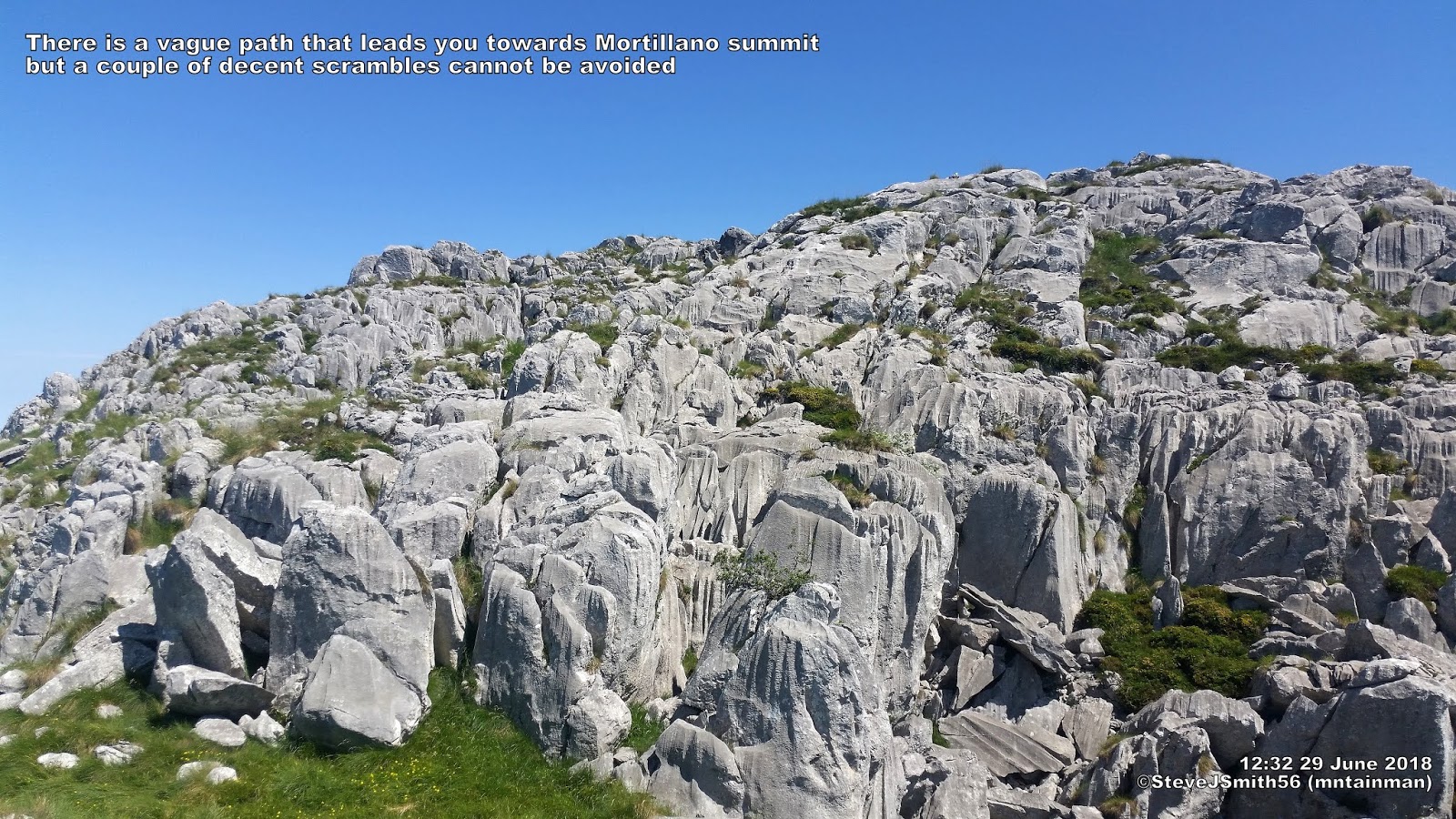 |
| There is a vague path that leads you towards Mortillano summit but a couple of decent scrambles cannot be avoided |
As you round Porra del Portillano you get your first proper view of Mortillano summit, up until then it has been Porra del Mortillano from the south.
Cross the saddle and pick the best route to the summit. There are vague paths that leads you towards Mortillano summit but a couple of decent scrambles cannot be avoided. The return is pretty much the same as the ascent though I never managed to find the exact route back I reckon the return tracklog shown in blue on the route map below is pretty much the route you want.
Normal hot sunny weather resumed (judging how green it is I guess The Cantabrican and Basque mountains get their fair share of rain) which I seemed to cope with better than I did on the first day up Ganekorgorta. Hopefully re-finding my hill legs and starting to adapt to walking in a hotter climate.
Walk Date - 29 June 2018
Walkers - Steve Smith
Walkers - Steve Smith
Accommodation - Camping Playa Arenillas, Islares
Start Point - Off road parking at track junction between K10 & K11 markers on CA-265 (N43°12'08.948" W3°34'53.786")
Start Time - 09:51
Finish Point - Off road parking at track junction between K10 & K11 markers on CA-265 (N43°12'08.948" W3°34'53.786")
Finish Time- 15:15
Total Duration - 5hrs 24mins
Overall Average pace - 1.20mph
Total Distance Walked - 6.47 miles
Total Height Ascended - 814.70metres
Overall Average pace - 1.20mph
Total Distance Walked - 6.47 miles
Total Height Ascended - 814.70metres
Peaks visited
Spain/Portugal 600m Prominence Peaks (168S - 185S&P - 2165E)
Mortillano (6S - 7S&P - 35E)
Spain/Portugal 300m - 599m Prominence Peaks (1000+)
NONE
Spain/Portugal 150m - 299m Prominence Peaks (3000+)
NONE
Spain Autonomous Community High Points (19)
NONE
Spain Province High Points (52)
NONE
S: Spain
P: Portugal
Other walks on this trip
2018
June
26th Ganekorgorta
28th Eretza
29th Mortillano
July
01st Castro Valnera
03rd El Cueto
Route
 |
| Add caption |
More Photographs
 |
| Follow track to left of first farm building. Can see Mortillano in distance to right of tree Click on photograph to view slide-show |