
Walk Summary
Rather than driving all the way from Cumbria after yesterdays walk up Calf Top, I headed south along the M6 with the intention of stopping at one of the service stations along the M6 or M56. That way I get a few miles in tonight that won't have to be driven tomorrow morning.
By 9pm I had got as far as Charnock Richard Services on the M6 so time to pull over and get myself sorted for the night .
I first did this earlier in the year on the way back from the Lake District after climbing Pillar Rock. For £12.00 you are able to park all night (24 hours actually) have use of a shower and of course access to the 24 hour services. I tend not to bother with these due to be able to brew up in the camper van and more importantly get my head down for a good nights sleep, but they are there if you need them.
Early(ish) start allowed me to reach Siabod Cafe car park in time to set off for Moel Siabod before midday, crossing the bridge over Afon Llugwy. It would be here that I would also spend the night, this time for just £5.00 payable in the cafe. A useful service with access to toilets used not only by a couple of other campervans but also people sleeping in their cars.
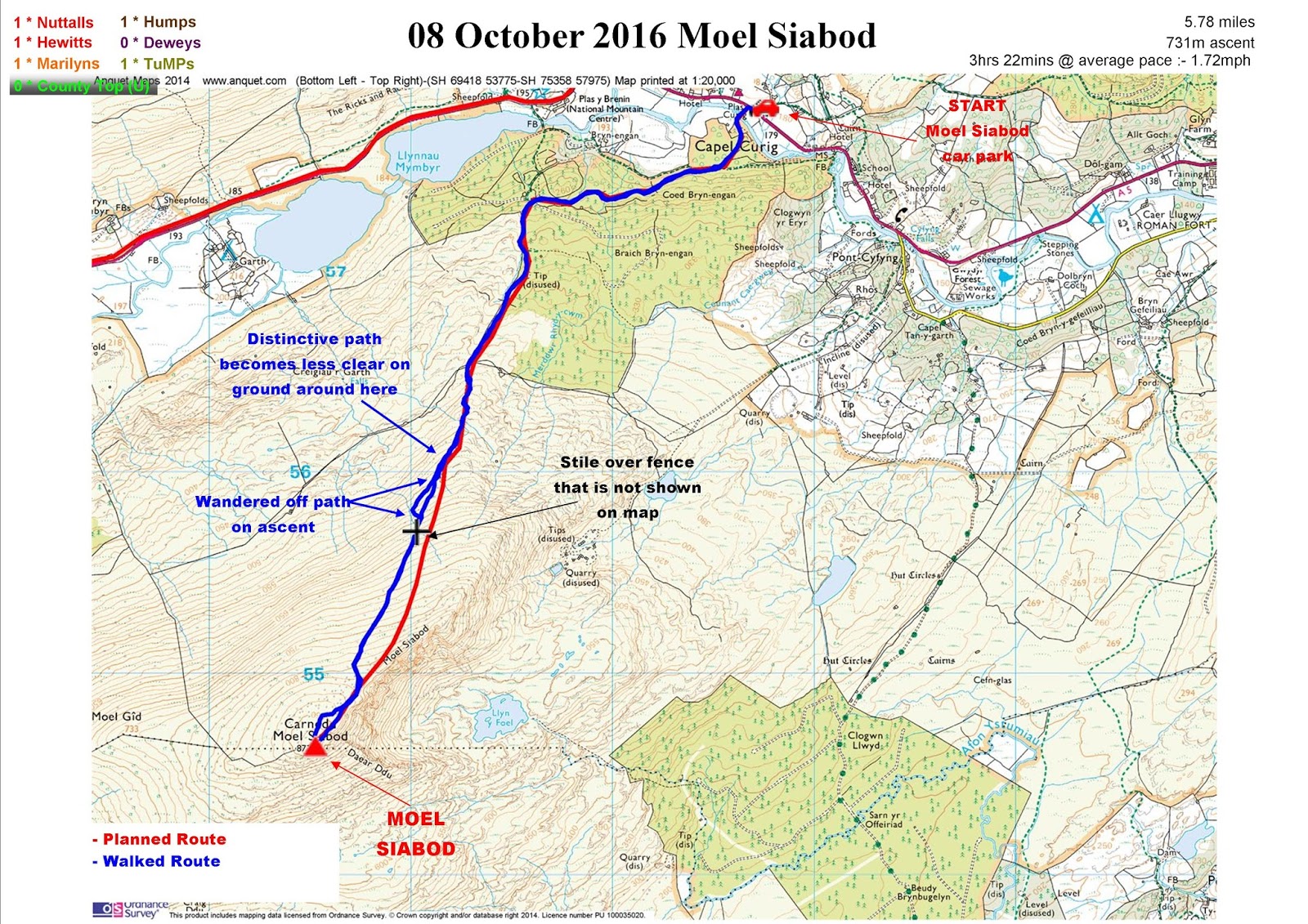
Not a lot to report really on what was a straight forward walk following first the forest track after the bridge and then the well worn path keeping the crags of the NE ridge on the left.
The summit area was fairly busy mainly with people enjoying lunch taking in the views, enjoying the unseasonably warm (even at nearly 3000') October weather.
I did consider returning along the NE ridge to get in a bid of scrambling practice but decided to head down along the same path used on the ascent, to make sure I had enough time for a cuppa and one of the massive home made cakes in Siabod Cafe.
Walk Statistics
 |
| Coming off summit looking ahead crags on SE side of NE ridge A more interesting descent route along the top |
By 9pm I had got as far as Charnock Richard Services on the M6 so time to pull over and get myself sorted for the night .
I first did this earlier in the year on the way back from the Lake District after climbing Pillar Rock. For £12.00 you are able to park all night (24 hours actually) have use of a shower and of course access to the 24 hour services. I tend not to bother with these due to be able to brew up in the camper van and more importantly get my head down for a good nights sleep, but they are there if you need them.
Early(ish) start allowed me to reach Siabod Cafe car park in time to set off for Moel Siabod before midday, crossing the bridge over Afon Llugwy. It would be here that I would also spend the night, this time for just £5.00 payable in the cafe. A useful service with access to toilets used not only by a couple of other campervans but also people sleeping in their cars.
Not a lot to report really on what was a straight forward walk following first the forest track after the bridge and then the well worn path keeping the crags of the NE ridge on the left.
The summit area was fairly busy mainly with people enjoying lunch taking in the views, enjoying the unseasonably warm (even at nearly 3000') October weather.
I did consider returning along the NE ridge to get in a bid of scrambling practice but decided to head down along the same path used on the ascent, to make sure I had enough time for a cuppa and one of the massive home made cakes in Siabod Cafe.
Walk Date - 08 October 2016
Walkers - Steve Smith
Accommodation - Siabod Cafe car park
Start Point - Siabod Cafe car park (SH 72762 57804)
Start Time - 11:56
Finish Point - Siabod Cafe car park (SH 72762 57804)
Finish Time- 15:18
Total Duration - 3hrs 22mins
Overall Average pace - 1.72mph
Total Distance Walked - 5.78 miles
Total Height Ascended - 731.37metres
Peaks visited
Nuttalls (189W - 444E&W)
Moel Siabod (163W - 418E&W)
Hewitts (138W - 318E&W)
Moel Siabod (114W - 294E&W)
Marilyns (158W - 1556E,W&S)
Moel Siabod (92W - 260E,W&S)
Deweys (241W - 421E&W)
NONE
HuMPs (364W - 2975EW&S)
E,W&S:England,Wales & Scotland
Other walks on this trip
2016
October
07th Calf Top
08th Moel Siabod
09th Yr Aran & Gallt y Wenaullt
11th The Manods & Moel Penamnen from Blaenau Ffestiniog
12th The Cnichts
13th Moel Hebog - The Beddgelert Three
14th Moel-y-Gest
15th Five Nuttalls of the Central Rhinogs
18th Rhobell Fawr & Dduallt
19th Rhinog Fawr from Cwm-bychan Farm
21st Gorllwyn & Drygarn Fawr
22nd Pen y Garn
22nd Bryn y Fan
24th Foel Goch and the four Deweys from Bala C&CC campsite
25th North West Arans
Route
More Photographs
Walkers - Steve Smith
Accommodation - Siabod Cafe car park
Start Point - Siabod Cafe car park (SH 72762 57804)
Start Time - 11:56
Finish Point - Siabod Cafe car park (SH 72762 57804)
Finish Time- 15:18
Total Duration - 3hrs 22mins
Overall Average pace - 1.72mph
Total Distance Walked - 5.78 miles
Total Height Ascended - 731.37metres
Peaks visited
Nuttalls (189W - 444E&W)
Moel Siabod (163W - 418E&W)
Hewitts (138W - 318E&W)
Moel Siabod (114W - 294E&W)
Marilyns (158W - 1556E,W&S)
Moel Siabod (92W - 260E,W&S)
Deweys (241W - 421E&W)
NONE
HuMPs (364W - 2975EW&S)
Moel Siabod (108W - 343E,W&S)
Historic County Tops (413E - 93E,W&S)
NONE
Historic County Tops (413E - 93E,W&S)
NONE
W: Wales.
E,W: England & Wales. E,W&S:England,Wales & Scotland
Other walks on this trip
2016
October
07th Calf Top
08th Moel Siabod
09th Yr Aran & Gallt y Wenaullt
11th The Manods & Moel Penamnen from Blaenau Ffestiniog
12th The Cnichts
13th Moel Hebog - The Beddgelert Three
14th Moel-y-Gest
15th Five Nuttalls of the Central Rhinogs
18th Rhobell Fawr & Dduallt
19th Rhinog Fawr from Cwm-bychan Farm
22nd Pen y Garn
22nd Bryn y Fan
24th Foel Goch and the four Deweys from Bala C&CC campsite
25th North West Arans
 |
GPX can be downloaded from
|
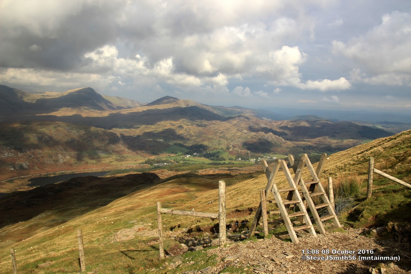 |
Looking back at fence with stile not on map SH 71030 55704
Click on photograph to view slide-show
|